Geometry of Rock Wedge
Entering geometry of a rock wedge using either gradient or falling line gradient direction requires a definition of space orientation of the rock face, terrain (top face), slip surfaces N1 and N2 and/or tension crack, such that:
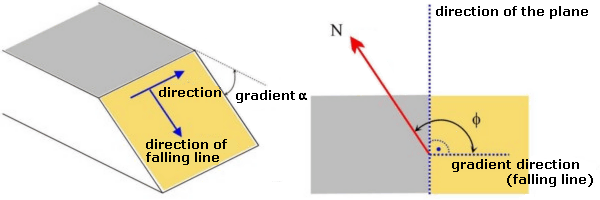
- Gradient of surface (gradient angle) is an inclination angle α representing inclination of the surface from horizontal (it may receive values from 0° to 90°). In case of overhanging slope (the edge of the slope is before the slope toe - wall tends from edge to the rock mass), then it must be checked button "Overhang rock face" and gradient of the face φ is considered in the half-plane of the rock mass. The program checks the possibility of overturning failure of the rock mass with the overhang rock face. If the option of an earth wedge overturning is realistic, the program notifies the user in the listing of the results. Howewer, the program does not make a real evaluation of the overturning or rotation of the rock wedge.
 a) Pendulous rock face b) Overhang rock face
- Gradient direction (falling line) is an angle b between the horizontal projection of the line normal to the strike direction measured as an azimuth angle from the north in the clockwise direction (the falling line corresponds to inclination of the plane), it may receive values from 0° to 360°.
The program when defining space orientation of planes displays these planes using a stereographic projection.
 Description of orientation of surfaces - using gradient and direction